No matter how many photos or videos you’ve viewed, I don’t believe you can ever be prepared for your first voyage through Te Aumiti/French Pass. The raw power and sheer violence of the monstrous volume of water cascading through the narrow 500m-wide passage is, quite simply, jaw-dropping.
Even in the ‘safe’ navigable passage closest to the mainland the turbulence is evident from inside the boat; the engine must work harder and, while the water is often flat-calm, the whirlpools and eddies are clearly visible. Large pressure waves off to the side add urgency to picking the right line. Sometimes it feels like you’re flying in an aircraft, hitting air pockets that punch you to one side.
But French Pass is just one small part of the overall D’Urville Island experience. Chances are, even if you’ve never been there, you’ve heard or read enough about Rangitoto ki te Tonga/ D’Urville Island to whet your interest in a visit. The question many people ask is whether it’s ‘do-able’ for the typical Kiwi trailer boater? The answer is yes, but with some caveats.
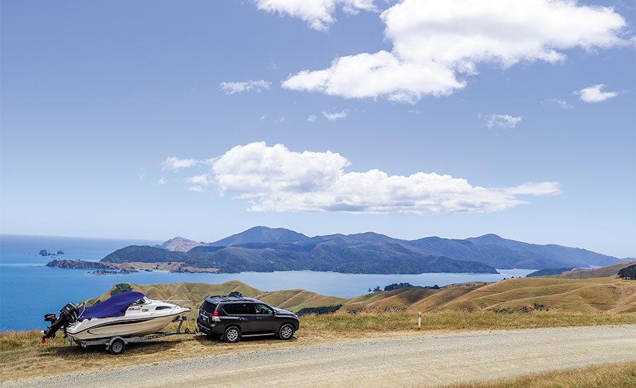
 On the road to Okiwi Bay – the adventure begins.
Situated at the top of the South Island and exposed to the most extreme wind, sea and sun conditions imaginable, the island and its surrounding waters cannot be taken lightly. If you’re taking your own boat you need to carefully consider your trip and be flexible with your plans around both location and timing.
The adventure truly begins once you turn off State Highway 6 halfway between Blenheim and Nelson, because from Rai Valley your car engine has to work that little bit harder to tackle that long, steep, winding stretch of road.
Okiwi Bay is a popular destination and in favourable weather is often used as a gateway to D’Urville Island itself. While it was tempting to stop and have a break, we opted to push on towards our final destination. From Okiwi the road gets narrower, more winding and soon turns to shingle. But, the views are breath-taking as you make your way slowly along the narrow peninsula that stretches out towards D’Urville.
The wide expanse of Tasman Bay lies to one side with the myriad waterways of Keneperu Sound on the other and the island itself looming large in the distance.
 Anaru, French Pass
In fact, the size of the island can be deceiving. Quite simply, it’s huge – about 150km2 or 16,000 hectares in size split pretty evenly between Department of Conservation (DOC) managed land and private farmland. While preparing for my first trip and poring over maps and charts, I figured I’d be able to travel certain distances, but the reality was rather less due to the ever-changing sea and weather conditions and the limitations of my 5.8m Fi-Glass Lightning. Again, this is something every boatie needs to take into consideration.
The small but quaint settlement of Anaru/French Pass is situated in Elmslie Bay and hosts large numbers of people and boats over summer. There’s a small store, a DOC-administered campsite, as well as several other accommodation options, but little else. And parking is at a premium, particularly when boat trailers are thrown into the mix.
The slipway [boat ramp] here is rudimentary. Narrow and facing into the prevailing wind and sea, it caused some anxiety for my 15-year-old son as he backed the boat off. The large nearby wharf can be used to load your vessel, or you can simply pull up onto the beach next to the slipway. It’s also important to note that there’s no wash-down facilities here.

I confess to an equal dose of anxiety and excitement departing the wharf, taking the boat around Collinet Point and heading through the famed French Pass for the first time. I couldn’t help wondering at the skill and sheer guts of Captain Jules Dumont d’Urville back in early 1827 when, after investigating the pass for several days, he took his sailing ship Astrolabe through for the first time.
Today, with navigation marks, the passage is a great deal easier but nonetheless can’t be underestimated. With the water travelling at around 8 knots and multiple, ever-changing whirlpools, pressure waves and eddies stretching hundreds of metres either side of the pass, you need to concentrate – and frankly – hold on. When there’s a strong wind against the tide, it’s even more impressive.
We soon pointed the bow along the eastern coastline of the island and made our way through a large and messy chop created by the strong south-easterly wind.
Kapowai Bay, just a short hop from French Pass, has a wharf, slipway and is also the end of the island’s road. A barge regularly takes cars and other goods between there and French Pass. Further on, Lucky Bay is the site of one of several small DOC campsites, but being exposed to the wind and waves made it unsuitable for us to go ashore and set up camp.
 Lunch – a fat blue cod
Catherine Cove is a large, sheltered bay that’s also the location of the D’Urville Island Wilderness Resort offering food and accommodation options. But our first night was spent on the boat, anchored in a small, sheltered cove and catching our dinner within a couple of casts. It goes without saying that the fishing around the island is exceptional and many stories have been written and shared about the size and abundance of the staples – blue cod, gurnard and snapper – as well as the almost legendary opportunities available to target large groper, kingfish and other species.
Kingfish around the island are renowned for their size and sheer power, but while we tried, we were unsuccessful in catching one this trip. Meanwhile, those keen to explore under the water will be astonished at the clarity of the water and the abundance of sea life.
Our intention had been to boat as far up the eastern side of the island as possible and after looking at maps and charts and studying the weather I figured it wouldn’t be unreasonable to venture as far as the Rangitoto Islands lying just offshore of the main island.
 A busy morning at the boat ramp, Okiwi Bay.
But the sea conditions dictate every decision and by the time we reached Half Way Point (yes, halfway up the length of the island) it was clear there would be no further travel. A quick ‘drop and go’ on the beach at Penguin Bay gave me an opportunity to check on the suitability of the DOC campsite, but again, it was clear that the wind and sea would make it an unsatisfactory anchorage.
The strong sou’easterly and messy sea saw us instead turn around and begin the long journey down the island and back through the pass. Once through, Current Basin was calm and we quickly made our way toward Sauvage Point and the western side of D’Urville. The sun came out, there was no wind and we enjoyed some wonderful time exploring, fishing and simply admiring the seascape, landscape and wildlife.
Interestingly, on another occasion we transited from the east coast to escape strong easterly weather only to boat straight into strong northerly conditions on the western side – and this seems one of the vagaries of the island; it can be blowing from one direction on one side but when you boat around to the other side to find sheltered water, you discover it’s blowing from another direction and the conditions are even more marginal! The fact the island is exposed to every facet of the weather should never be underestimated.
 Edging into the shallows.
Our second night was again spent anchored in another secluded bay with a setting sun, fast dropping wind and fresh fish and mussels. Later, we fell asleep with the Milky Way bright above us. It was bliss.
Our final day dawned clear and calm, but with the nor’wester expected to pick up mid-morning we only had time for a quick fish before heading back to the slipway at French Pass to begin the long drive back to Christchurch.
Like with any boating trip, preparation is vital and, when visiting D’Urville for the first time, it takes on an added dimension. The internet is a treasure trove of information with plenty of reading and viewing about navigating French Pass itself, although the best and most up-to-date information can be gathered by asking locals or other experienced D’Urville boaties.
Accommodation can be sourced via Book-a-Bach and similar websites, while D’Urville Island Wilderness Resort at Catherine Cove offers a variety of options if you want to stay. Given a large part of the island is administered by the Department of Conservation, its website offers plenty of information on activities and facilities, including campsites.
The Marlborough Sounds Cruise Guide is an interactive and highly detailed website/app that offers descriptions, photos and even drone footage of bays, anchorages and facilities. The information is displayed in a map format that’s easy to use and navigate.
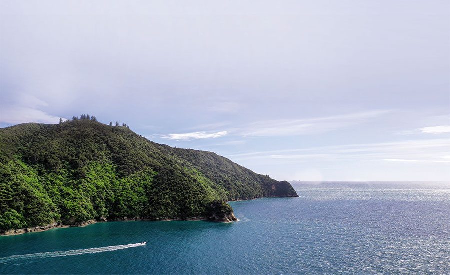 Exploring the island’s coastline and, inset, French Pass.
And it’s hardly surprising to discover that there are many dozens of videos on YouTube that provide a colourful glimpse into the fishing, diving, hunting and boating around the island. If nothing else, they’ll whet your appetite!
PredictWind.com, MetService and Windy.com provide good quality marine weather forecasting while VHF radio communication is available via numerous channels.
So yes, boating the island with a ‘typical’ trailer boat is manageable, but as I hope I’ve covered, it needs to be undertaken with a great deal of care and consideration – not to mention a dose of good luck with weather. You need to be flexible in your plans: have a general idea of where you want to go, but be prepared to shelve those plans. And, with no cell coverage, a secondary means of communication to complement your VHF radio takes on even greater importance. We had a Personal Locator Beacon onboard.
If you like long, windy and dusty road trips, then a visit to French Pass and D’Urville Island is just for you. You may well see me, but next time I’ll have a bigger boat and more time to spend.BNZ