With 77 atolls sprawled over 130,000 nautical miles in the South Pacific east of Tahiti, the Tuamotu Archipelago is a stunning ocean treasure. It’s also dangerous.
I am just about to drop the anchor in 9m of jewel-like water in Tahanea Atoll, another perfect gumdrop in French Polynesia’s Tuamotu Archipelago, when I spot three black-tip sharks circling OCEAN, our Dolphin 460 cruising cat. Silly thoughts follow: What are they doing here? What do they want? And why now when we are in the middle of anchoring?
A half-boatlength ahead, Harriet is in the water in fins and mask, scanning for a sandy patch among a seabed peppered with coral bommies. Suddenly she signals drop here. I jump from the helm to the foredeck and press the ‘down’ button on the windlass, rust chips flying as the chain rattles out. The 20-knot trade winds blow OCEAN back quickly. I’m clipping anchor floats onto the chain, every 10m, as 50m feet of chain pays out. When I scuttle back to the wheel and throttles, I hear a cry from Harriet: “TL! Can you keep an eye on me? There’re sharks over here!”

I stand watch on the cabintop as she swims back to OCEAN, her head swivelling 360 degrees. I’m watching for sharks so I can – what? Jump in? Launch the dinghy? The dinghy is in the davits. The men in the grey suits disappear just as Harriet hauls herself onto the port swimstep.
There’s nothing like a visit from Tuamotus sharks to punch up your adrenalin level. Maybe they sense a vibration, our primal fear. Other cruisers have told us: Hey, don’t worry. Sharks are not interested in your skinny kicking legs and fluttering swim fins. You don’t look, smell, or move like prey. Well, thanks to Stephen Spielberg, Peter Benchley, and Jaws, we are pretty much ruined when it comes to sharks. But during our two months in the Tuamotus, where beauty means danger, sharks became just another wonderment of a stunning immersion into nature.
The Archipel des Tuamotus, a territory of French Polynesia, stretches 780 nautical miles northwest, from 19° to 15° South, and features 77 atolls and in reefs. The Marquesas island group lies about 420 miles to the northeast; Tahiti is about 170 miles southwest. Back in 1988 when we crossed the South Pacific in freelance, our 28-foot Bristol Channel Cutter, we’d visited Rangiroa, the largest atoll of the Tuamotus, where we were dazzled by the 25m water visibility and the dolphins leaping in the standing waves of the reef pass. But even though the Tuamotus are well-charted, back in those pre-GPS days we did not dare take our boat into the midst of the atolls. Like the Portuguese, Dutch, French, and British voyagers of hundreds of years ago, we saw a labyrinth of potential disaster.
In good light, Tuamotu atolls become barely visible about eight miles away – a faint greenish fuzz of coconut palms. Lights and navigational aids are exceedingly rare. The atolls are nearly steep-to, with 350m to 800m depths that shelve sharply immediately before the reef. Unpredictable currents trickle and swirl among the atolls. Reef passes into the atolls are only safely navigable with the right combination of visibility (no overcast, sun behind you, never at night) and current (more than 2-3 knots with or against you can be dangerous).

Armed with our paper charts of the Tuamotus from 1988, our near-new Raymarine chartplotter and multiple backup GPS handhelds, a 48-mile radar mounted at the spreaders, and two 40hp diesels turning three-bladed folding props, we decided to delve deeper into the archipelago this time and visit a halfdozen atolls. We waited for a spate of southeast trade winds to back into the east, and we departed the Marquesan island of Ua Pou for the Tuamotus.
Forty-nine hours later OCEAN arrived off Rairoa Atoll to a sunrise surprise: water was rolling out of the pass at five knots. We hove-to, waited for good light, and re-consulted our tide tables and the Tuamotus Tide Guestimator, a useful tool in the Tuamotus Compendium (https://svsoggypaws. com/files/#frpoly), a searchable PDF of cruising reports compiled (and updated) by seasoned South Pacific cruisers. The Guestimator calculates slack water and maximum tidal flow in a given pass using inputs of lat/long position, local time and tidal data, and a Wind/Wave factor (estimated swell height, wind speed, direction, and duration).
On freelance, Harriet had consulted the moonrise tables of the Nautical Almanac (in those days we navigated by sextant and dead reckoning) to find the time of slack water – when the moon was directly underfoot or overhead, water flow in the pass was minimal. Of course, the Nautical Almanac could not account for the effect of swells and wind like the Guestimator. Even with this modern tool, we concluded that calculating the flow in a reef pass is still a bit of a black art. We entered the pass of Rairoa Atoll against two knots of current, and we kept the mainsail up, the jib ready to unroll, and the anchor ready to go should the engines die, or the props become fouled.

Once inside Rairoa Atoll, the feeling was, simply, amazing. A wide expanse of board-flat, gorgeous water in a million hues of blue. Motus of white sand and swaying coco palms stretching away to the far side of the lagoon. The whisper (or roar!) of the reef. And loads of coral bommies. Some atolls have trustworthy marked channels across the lagoon, but otherwise a constant lookout, with clear verbal and hand signals to the person on the helm, is mandatory. We transited the lagoon, 13 miles in 18m to 30m depths, past bommies rising to within a few feet of the surface, to the southeast side of Rairoa and joined a half-dozen cruising boats anchored in the lee of a motu.
Courtesy of a friend of an island friend of an island uncle and two island aunties, we joined a pot-luck picnic at a shack near a cut in the reef. Out came the food, the drink, the fiddle, the guitars, and the ukeleles, as a pet pig, a dog, and a fiveyear-old boy circled around our feet. During the course of this afternoon, we made new cruising friends, learned a few phrases of Tahitian, and realized that in French Polynesia, ukeleles rule. Rairoa Atoll has a small airport but does not have a bustling tourist trade, and life has remained close to its Polynesian roots. People fish, cut copra, do some pearl farming. For many in the older generation, picking up a ukelele and singing is as natural as breathing. For over a week, we soaked in this special place.
We’d heard that Tahanea Atoll, a national park and seabird sanctuary about five atolls to the west, was a true treasure. The trick when going from one atoll to another is to time your departure and arrival when the reef passes are passable. We hatched a plan to leave Rairoa in late afternoon on a ‘go slow’ 100-mile overnighter, so we’d arrive at Tahanea in good light, when the pass would be ready (incoming tide). We plotted a course that would take OCEAN north of Taenga Atoll, around the west end of Makemo Atoll at about 0200, then between Katiu and Tuanake atolls, arriving at Tahanea around 0800. In theory, the trade winds would be less than 15 knots, the sea state slight, we’d have the chartplotter and handheld GPS units going, and we’d advance our position on our trusty paper charts.

We left Rairoa, the sun promptly set, and we found that sailing among the Tuamotus on a moonless night is spooky. The darkness was the kind of darkness known as total darkness. We saw nothing the entire night but a sprinkle of masthead anchor lights on yachts in Makemo, poking above the palms. We had childlike faith in our digital position finders, but still – what if the GPS readouts were glitchy, a few miles off? We looked to our radar to add an element of reality to what otherwise was a video game delivered by satellites. The radar picked up the motus and the wrinkle of surf over the reefs, and with the chartplotter overlay selected, the radar helped confirm our position when it laid the radar return right over the chartplotter images. Which helped immensely as we eased through the six-mile gap between Katiu and Tuanake. We entered Tahanea’s Passe Teavatapu, deep, wide, and easy, in favourable light with a gentle one-knot incoming tide. Thank you, Guestimator.
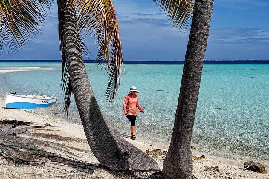
Tahanea Atoll was lovely. A pristine 25-mile-long lagoon. Empty motus, nothing but sand and coconuts and coconut crabs. No tourists. No hotels. A few cruising boats. Manta rays gliding back and forth in the shallows of the pass. You think: After all the years of preparation, of sailing thousands of miles, well, here we are. Paradise. South Pacific Paradise. Yes, it really does exist. As the blight of fly-in tourism spreads across the globe, Tahanea Atoll, at least, may escape for a while.
We spent two weeks at Tahanea, revelling in one of modern life’s most underrated luxuries: time. What did we do with all that time? We read (see ‘The Things We Read’ sidebar), we sailed our dinghy, we went for walks on the motus, we tackled an odd job or two on the boat, and we drift-snorkelled the pass (motor the dinghy out the pass on an incoming tide, jump in the water, and the current takes you – and the dinghy – on a scenic ride back into the lagoon).
Next, we daysailed to Fakarava Atoll, National Geographicfamous for its diving, where we found that fly-in tourism had arrived. A modern airport has put the atoll on the bucket list of world travellers and put money in the pockets of dive shops and resorts. The main anchorage, packed with 50 yachts, feels like crunch time at the Bahamas. The flood of needy yachties is overloading the mom-and-pop magasins, and there’s a crowd rush when the supply boat comes in. That’s just what happens when a place becomes too popular, right?


We headed next for Kauehi Atoll, hoping to find a laid-back respite. And we did (the atoll has only recently been opened to tourism). Kauehi is not only beautiful but also peaceful. We anchored well away from Tearavero, the village, and discovered, as at Tahanea, that we had no internet connection. Which was wonderful. No Facebook, no avalanche of awful news – no Trump, no school shootings, no inflation, no crazies with assault weapons, no Trump. We were hiding from the world. We had escaped, but we’d be back into the noise soon enough.
We could almost feel the people slipping away from Kauehi – abandoned homes, only one magasin, only fishing and copra, the supply ship maybe doesn’t come as often as it used to. If you grew up here, you’d go to Tahiti. And, strangely, Harriet and I began to feel the tug of Tahiti. Not that we wanted to go to Tahiti – we’d been there before, and we knew it was Civilization, with all of the usual thrills and ills. But we had a few things to attend to on OCEAN, and Tahiti has marine chandleries, hardware stores, sailmakers, riggers, and major supermarkets. But first, we needed to revisit Rangiroa Atoll, which had made such a powerful impression on us 35 years ago.
These days, it is not a good idea to return to a place you remember fondly, because things change. After a squally, bouncy overnight trip from Kauehi, we arrived at Rangiroa’s Tiputa Pass – the first French Polynesia reef pass we’d ever experienced, so exciting, so dolphin-filled, so amazing. But now, every day, the pass is chockablock with dive boats, the tourists gawking at the dolphins. Several large, tourist-laden poweryachts came steaming out of the pass as we tried to go in. We made our way into the lagoon and found that 40 cruising boats had overstuffed the anchorage – last time, there were only three – and a four-star waterfront resort, with requisite overwater bungalows, had taken over the shore. Rangiroa Atoll was officially a Destination.

We couldn’t leave the Tuamotus in such a disillusioned state. Our last stop would be Tikehau Atoll 45 miles to the west. Entering shallow Tuheiva Pass, where a 13m French sailboat had been thrown onto its beam ends on the edge of the coral, we anchored off an abandoned pearl farm, near a sleepy resort. After the frenetic pace of Rangiroa, Tikehau seemed relaxed and relaxing. No speeding dive boats. No blasting jet-skis. The tourism is low key. Possibly even affordable. But it was time to go. On to Tahiti! Only 162 miles.
The Tuamotus were outstanding. We felt grateful and privileged to be able to experience such oceanic riches. We hear that most of the atolls – after all, we’d only dipped our toes into six – remain largely untouched, and that their bird life and sea life continue to flourish. That includes our new friends, the black-tip sharks. BNZ